
Speaker 1 (00:00):
... from Elaine. It was a year and a half ago that we asked the American people in the Congress to give us the money to actually build a brand new air traffic control system. And it was a year ago the Congress gave us 12 and a half billion dollars. And with that 12 and a half billion, what we did was we built and deployed brand new radar, radios, voice switches, surface awareness systems. We are going from the old copper wire that you used to use on your rotary phone, if you're old enough for that. We're going to high speed fiber. We're going to move from analog to digital, which is going to be the infrastructure that's going to bring more resilience and safety into our air traffic control system. All really important. But if you ask the American people, what do they want? They want a better flying experience. They want less delays. They want less cancellations.
(01:05)
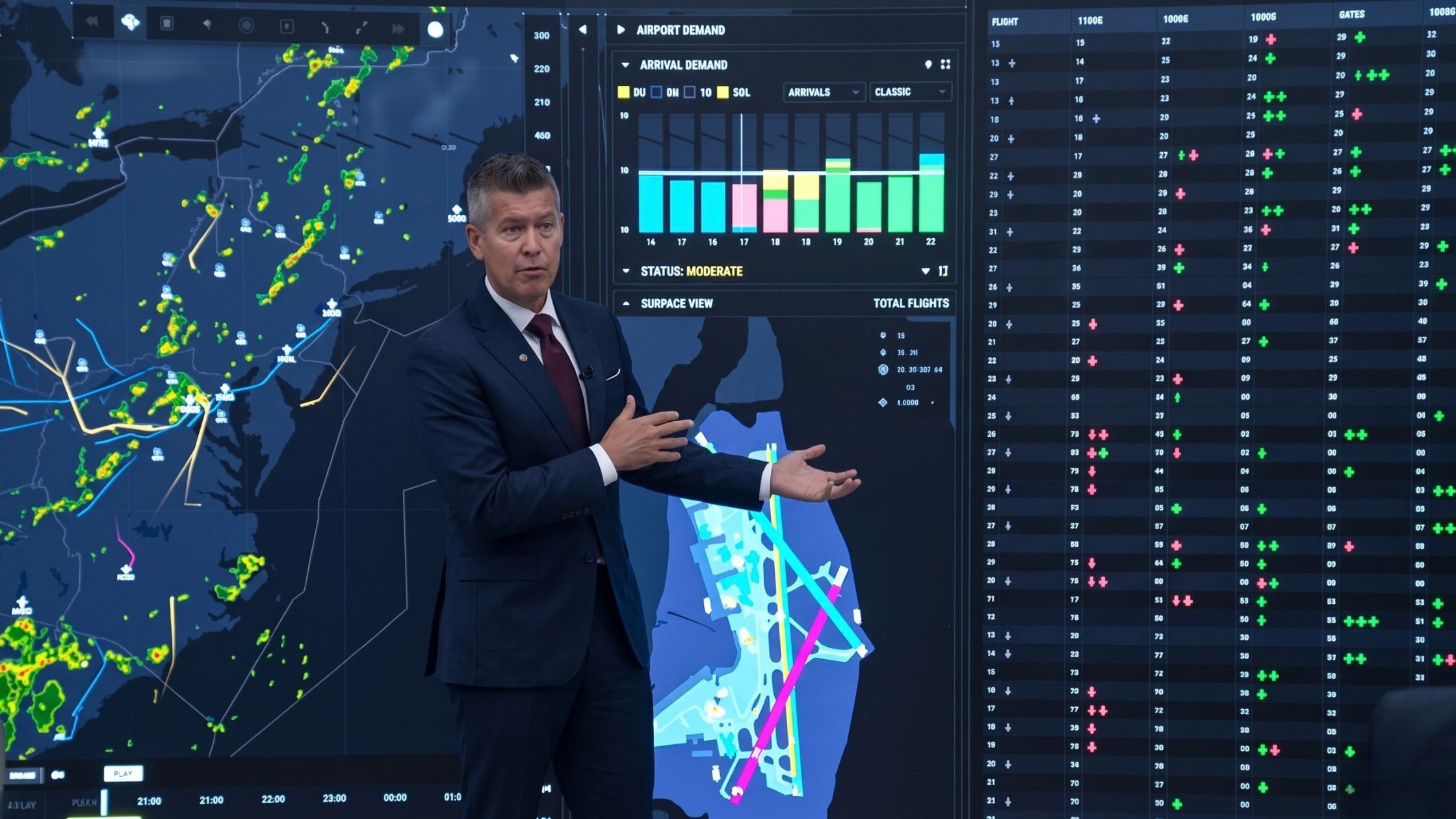
And though we have a new radar and new radios, which is again more resilient, it doesn't drive the efficiency that the American people are looking for. And so today we are going to show you what we call our SMART system, which is Strategic Management of Airspace routes and Trajectories. This is important because we are taking 200 data points out of our system and we're looking at weather. Maybe we'll show up some of the weather here. This is live footage, Bernard, right? So as we sit today, this is a live look at the American airspace, airplanes, weather throughout the system. So we take the weather data, we take flight path data as well. And then we look at arrivals and departures. So our blue is departures, our orange is arrivals. And if you saw magenta or pink, that means we have an issue with that flight. There's a diversion for that flight path.
(02:12)
But all of this data is important for us because we're able to use that and not just look in real time, we are actually able to use predictive data to see where flights are going, where weather is not just right now, but where weather is going to be in the future. So I want to pull up a picture of what the system looks like today that humans use to control... I'm so sorry. This is what we use. Okay. This is a workstation that a person sits at and they get multiple different data points in real time and have to compute in their head the best path to manage the airspace.
(02:57)
Really hard, a lot of real time computations and humans sometimes don't make the best decisions. Our system actually takes all of that data and gives a prompt to a human on how to better manage the airspace. I want to be really clear. There's been a lot of conversation about AI and who's controlling the airspace. This is a predictive tool that will give a prompt to a human, to someone who's managing the airspace, but it's always going to be a human that manages the airspace in America. So this tool won't manage the airspace, but it gives us better information, better data to manage the airspace on behalf of the American people.
(03:44)
If I could do one thing, let's go back to the real time map, Bernard. What's great is, so you have a view of the country as a whole, but we're here at... Let's go to DCA. So we can zoom into the DCA airspace, all the arrival and departing flights. But if Bernard's like, "Well, who's on the ground? What's happening at the airport itself?" Bernard can zoom in and we get a real time look what airplanes are at the gate, what airplanes are prepping for departure. We can pull up what the aircraft is. This is a JetBlue flight. We all know how long it was since they've left the gate. In real time, we get all of this data so we can see how long someone has been waiting as they look to depart. And we got a little red plane here, which means it's been there a little bit too long.
(04:33)
So it's this tool that's going to get better information, weather, flight paths and schedules that are going to help us provide a different experience for the American people. I want to be clear again, this has not been deployed anywhere in the world. America was the first in flight. We're the ones that helped the world set up air traffic control. And we are again leading the world in new technology to bring more efficiency and a better experience to the American people. The guy that has been the driving force behind that is our administrator of the FAA, Bryan Bedford, who has been remarkable in being a visionary of bringing this new tool to bear. He's going to walk through the different scenarios in which the tool is used, predicatively, to help us get better results for the American air traveler.
(05:28)
And one last, this is what America's asked for. They said, "Hey, I'm sick of the experience that I have right now in America. I'm sick of the delays." We both get so many texts from friends and family and colleagues, maybe from you and the media as well. This is our effort to give you a better system, better tools and better efficiency as we move forward.
(05:52)
So I gave you the administrator of the FAA, the visionary behind this product, Bryan Bedford.
Bryan Bedford (05:57):
Wow. Thank you for that. If I could go back to the first slide of the old workstation just for one second. What we have here again are the best tools that the FAA has today. Best weather tools, best radar tools, best ADSB tools, best paper chart tools. I mean, really amazing paper charts. If you could somehow look at the lines on this paper chart, that's how airplanes fly today. It's the way they flew back in the 1950s, the 1980s. It's the way they still fly today on these Victor Airways. But as the secretary said, a human has to sit behind all of these static pictures and formulate an understanding of exactly what's the best way to move traffic. Really important point here. This is not a traffic safety, traffic separation tool. That's not what this guy's doing. He's not actually talking to airplanes and saying, "Do a course correction because there's a conflict." Those 15,000 humans are still out there doing exactly what they were doing yesterday. They're doing that today. That's what they're going to continue to do.
(07:11)
This is a traffic management coordinator that sits here. He's a traffic data analyst, and he is trying to take all of this data in and form a picture of how they should either close airspace or open airspace. They're making these decisions that affect thousands of flights. So that's how it's happening today. Keep in mind static, two-dimensional.
(07:34)
Now we're going to go to the future where we now have an ability to look at not only active airspace design. So if we go to just what's happening today, we'll give you the continental picture. And if you put that in motion, what do we think this airspace picture is going to look like over the next hour, two hours, three hours. Keep in mind this traffic is flying on those paper chart airways. You can see they're taking very, very precise routes. Those flight paths haven't changed. And when we wonder why it takes longer to fly from point A to point B today with all this new technology, it's because there's a lot of traffic out there. It's the LA freeway system. Say again? You need me-
Speaker 3 (08:27):
Instead of standing in front of a black wall, if you'd stand in front of the-
Bryan Bedford (08:30):
Oh, sure. I apologize. Yes. So now we actually have an opportunity to look at holistically what's going on in the airspace, not just at this minute, but what we project will be going on in the airspace over the course of the day. And if you'll notice the weather isn't static anymore, the weather is moving and it's not just static at this level. Here we're at the ground level. Let's go and see what the weather looks like at 33,000 feet, and you get a different picture.
(08:57)
So when the FAA today is taking the best information it has, which is ground based weather, it's making decisions on opening and closing airspace based on an inaccurate understanding of what weather is at altitude because it's different. So we're getting now much better decision-making capabilities. Now how does this affect real flights, real Americans? So we pulled an example of August 10th. It was a day that we were sitting in here Monday in the capital region. We saw weather coming in and we were just curious how this tool might affect our decision-making. So we're going to let you take a look at the DCA picture. We've got weather coming in and we've put this in motion for you. These are actual flights that flew on the day and just hit pause for one second.
(09:49)
And again, we have a complete airspace understanding of what's happening. What are the planes wanting to do? Where is the weather? And then down here at the bottom, this informational chart is telling us decisions that the local FAA traffic managers have made to either implement ground delay programs or ground stop programs. And so you see all of a sudden the blue lines turn magenta. They have been given a delay. They've said, "Hey, we aren't going to be able to get you into DCA the way we thought we would. You guys could start flying in circles." This happens to lots of folks. "Hey, but we think we can squeeze you guys in to the south and to the east and get you into DCA before the storm gets there." That's a decision that a traffic manager made and communicated to planes to change their flight paths.
(10:46)
Again, but it was a bad decision based on bad information. This was telling us... Just stop here for a second. This is telling us that the storm is moving much faster than what our static picture of the storm was doing. So we set these really long multi-hour programs in place and the storm itself was going to pass in like 40 minutes. And so we had this huge effect on the front of the storm. We had the error in terms of how we were directing traffic. I mean, the idea was right, if we could get planes into DCA before the storm, close the airport, that's the right concept. It was just bad data. The better data would have understood that the storm was moving much faster and to keep that traffic to the west of the storm so that once the storm passed, they would be able to easily get back into the airport.
(11:40)
So you're going to see an example. Let's go to the Southwest example. So here, just pause and I'll introduce this for a second. We have a Southwest airplane who was given one of those trajectories to go to the south of the storm and come up into Reagan. But again, the storm's moving much faster. So it was the right idea, but the bad application. And so here the Southwest flight comes in. We can put it back into motion now. He makes a couple of circles. This fellow got in. By the time Southwest gets here, they're saying, "Hold on, hold on. We're not feeling good about this." He does a couple of circles. These guys are all circling, and now he's diverting to Norfolk. And we ended up diverting about 11. I think we diverted 11 flights during this storm that shouldn't have had to divert. And this is one hour in the life of the national airspace system for one airport.
(12:43)
And then as the storm passes, we'll get sort of into scenario three here, I point you back down here to we put these programs in place and once the program is established, that's it.
Speaker 1 (12:56):
The ground stop, right?
Bryan Bedford (12:57):
The ground stop or the ground delay program. Once a traffic manager makes a call, that's it. We don't go back and Monday morning quarterback it. But we're sitting here in the lab going, "Well, gosh, the storm has now passed." And actually we're physically here. It's a light rain. And so we're wondering what's the ground picture look like at Reagan at this time? And what we see is a long line of aircraft sitting at Reagan that are just waiting to take off. And they're asking the same question that most customers are asking on the plane, "The weather's gone. We're here. We're at the end of the runway. Why won't they let us leave?" And the answer is down here. Well, I can't. A traffic manager has said, "We're in a ground stop program and I have to wait till the ground stop gets lifted."
(13:48)
So the air traffic controllers, they're asking the same question, but they just don't have the authority to let the flights go. We were able to actually work with the command center just to sort of test the idea, can we let airplanes start to move? And we got the first guy out, he goes, and we can keep it in motion. Once we get the first guy off the runway, then they all start to leave and everything's fine. So again, just more precision is what we're talking about with this tool. So we think we can use better predictive analytics and we can use the better understanding of how weather is evolving and its intensity and at altitude and we can make much better airspace decisions.
(14:37)
So once we got him out, now we're getting more airplanes out, we're getting more airplanes in, and we saved about an hour and a half of what would have been a continuous ground delay program at Reagan. We were able to get traffic moving again. Even with this, when we put these ground delay programs, we do them in tiers. You probably have heard of a tier one ground stop or a tier two or a tier three. In this case, when the storm was over here, we implemented a tier three ground stop. Which essentially, if we could zoom out, Bernard, you would see all the traffic from the West Coast and Midwest, it's not flying anymore. These guys are all delayed. Everything else is now being held on the ground.
(15:21)
Well, those flights aren't going to get to Reagan for three or four more hours. And we know that storm is going to be gone and yet we made a decision to do a tier three ground stop. And so now we have 90 flights that cancel, 11 flights that are diverting, and a lot of that would have been avoidable. And that's what SMART can do for us. And that's how SMART can affect real customers in real time. You want to keep going?
Speaker 1 (15:50):
Do you want show one more and I'll finish.
Bryan Bedford (15:53):
Yeah. So here's an example of Reagan. We get the first flight out. You can see all of these airplanes stacked up here. And for those of you who fly in and out of Reagan as often as I do, I'm in there at least twice a week, there's no place to park airplanes. We have single taxiways and single alleyways into each of the concourses. So if we don't keep traffic moving, you get to a point where you are constrained, you have just absolute ground congestion and things can't move. So when we can move airplanes safely, we need to move airplanes. And this will be a little bit of a cultural change, I think, is to make sure that when the airspace is safe, we allow controllers to actually release these aircraft and get them flying again.
(16:43)
And so the final issue over here is talking about more of the efficiency. So you can tell here today, we're actually using one arriving runway. Reagan is a single runway airport. Today it's a slot controlled airport. What the system can tell us is every hour of the day, every minute of the hour, we can see, in this case, these are airplanes that have physically landed. These are airplanes that are in the air with their estimated time of arrival to the minute, and we can see several occasions where we have two airplanes that are scheduled to arrive at exactly the same time. Here we have three. I can't have three airplanes arriving at Reagan at exactly the same time because they're all going to compete for that single runway.
(17:36)
So today we ask the air traffic controllers to fix this. "Hey, can you guys, when the three airplanes are all approaching Reagan at exactly the same time, you guys decide how we should do this. Should this be extended miles and trail? How do you want to separate that?" Well, the SMART system will allow us today to start making subtle flight path changes where we can actually speed up one of these flights five knots and get it a minute ahead of the other one. We could slow one down five knots and put it behind the other airplane, so that by the time the traffic arrives to Reagan, it's already sorted out. And these are very modest flight plan changes.
(18:19)
Now, when we demonstrated this for the airline CEOs a few weeks ago, I think it really opened their eyes about the inefficiencies in the airspace and how much work we're asking our controllers to have to sort out, when we can actually use automation to sort that out and we can fix it before planes even leave the ground. And so you see another thing, you see all of these voids. We think of Reagan as a highly constrained slot controlled. There's no more room at Reagan. That's actually not true. We've got significant inefficiencies here where we can better align capacity to demand and we can actually create more convenience for customers.
(19:04)
And it's all just about getting better data clarity and enabling traffic coordinators to make better decisions to allow air traffic controllers to do what we really need them to do, which is maintain safety of the system and traffic separation. And that's in a nutshell. So starting today, we are now making those subtle trajectory changes and we're making advisories to the command center on weather. So as they're developing weather programs, we're collaborating with them on how those programs will come together here in the capital region. So again, we're focused on just the three primary airports at Reagan, Baltimore and Dulles.
Speaker 1 (19:51):
Yeah. So again, this is a national capital region, BWI, Dulles, DCA, this is where we start. And that's what we do at the FAA and DOT. We start small, we test, we validate, and then we expand from there. But if we better manage weather and better manage flights, again, speeding up or slowing down, so when you get to the airport, there's a runway that's ready for you to land on as opposed to circling. You're going to be on the airfield much faster. Your airline's going to use less fuel. And again, these are predictive tools, and I want to reiterate this. We are not outsourcing aviation to AI. That is not what we're doing, but we're using predictive tools to help humans better manage the airspace. And the tools we use are 30, 40 years old. It's not really new technology. It's really old technology. What we've thought through is let's use the best technology possible, the best predictors possible so humans can make the best decisions possible.
(21:05)
And when we make the best decisions possible, that means you have less delays and you have less cancellations, which means your experience in the airspace is way better. I think this is what the American people have asked from us. They've asked for a better experience, a safer experience, and this is a lot of work, a lot of effort by our teams to deliver for the American people. There'll be a lot of questions, but I want to be clear. Humans control the airspace, humans make decisions, but we're just giving them way better technology, way better foresight. And so we're excited about what this is going to bring in aviation. And just as people are like, "Is it going to change my whole experience for Christmas?" Maybe not by Christmas. We slow roll this, but as I look to next summer and as we roll this out further, I think you're going to see a gradual improvement of the airspace as you fly.
(22:03)
And that's what we're here to do. We're here to move at the speed of Trump and we're here to deliver for the American people. And with all the new equipment in the airspace as well as new tools, this is the deliverable of what no one else has in the world that we're doing first in America to change the way that you experience air travel. So kudos to the FAA and the administrator, ASI for the work they've done. They're our partner on the tech side. And thank you for checking this out. The future of aviation is months away as we deploy these new tools. Thank you. Appreciate it.
Speaker 3 (22:40):
All right. So for our print folks, we're going to just head over to another room because the audio here isn't great. So if you guys can with our staff, we're just going to pop over. We'll do the print gathering folks.
Bryan Bedford (22:48):
I'll take that. Well done.